
Brisbane Gateway Ports Area Strategy
An Assessment of Environmental Impacts
and Risk Factors
Prepared by
Eco-justice Praxis Group
Social Action Office
Conference of Leaders of Religious Institutes, Queensland

June 2000
INTRODUCTION AND ACKNOWLEDGEMENTS
The subject of this report came to attention when a number of people associated with the Social Action Office (SAO) participated in a bioregion workshop conducted by Michael Petter as part of the Eco-Soundings Program. The workshop involved a tour around many important environmental sites in the Brisbane bioregion including the mouth of the Brisbane River. The end result of this was that people became aware of the Brisbane Gateway Ports Area Strategy and very interested in the environmental consequences of this. Ben Glass, who is a member of SAO’s Eco-justice Praxis Group, also wrote a Briefing Note on issues related to Moreton Bay/Quandamooka and this again highlighted issues related to the Strategy.
As a result, the Praxis Group decided to pursue this study and then use the knowledge gleaned to engage in conversations with various stakeholders. So, this is a step in a process of raising awareness of the issues uncovered and of demystifying a specialist area and enabling more citizen participation in important decision-making processes.
This research report is not the work of a trained environmental scientist and it may have limitations. However, the fact that this report is prepared by non-experts is a strength. It illustrates that lay people can take hold of an issue which is often the exclusive province of specialist experts. It also extends knowledge by making it more accessible to the wider community.
The preparation of this report was assisted by information provided by the Port of Brisbane Corporation and the Brisbane Airport Corporation Limited. We acknowledge that the maps used here have been taken from recent reports of these organisations. The Moreton Bay Marine Parks Operation Base and the Environmental Protection Agency also assisted with information. Mr Barry Wilson generously lent several reports which proved to be invaluable. A special thanks to him. Michael Petter must also be thanked for his inspiration and willingness to talk and share insights.
The SAO has become more involved in environmental issues in recent years. This reflects a growing awareness that the whole Earth Community is linked in a web of interconnectedness and that this web of life is threatened by a convergence of forces which puts all species, not just humans, at serious risk. This awareness is also engaged theologically, connecting the cry of the oppressed with the cry of the Earth. The Eco-justice Praxis Group seeks to promote a spirituality of the Earth Community and to find a new pathway which will enable human beings to construct an economic and social reality based on justice, respect and mutuality and which encompasses the natural world. It is hoped that this report will open up vistas for readers, lead to reflection and inspire active political ministry. This is the praxis of which this report is a part.
Eco-justice Praxis Group
Social Action Office
Conference of Leaders of Religious Institutes, Queensland
PO Box 3246, South Brisbane Q 4101
Ph (07) 3891 5866
Fax (07) 3891 6944
E-mail sao@uq.net.au
June 2000
i
Table of Contents
1. The Brisbane Gateway Ports Area Strategy
2. Focus on the Port of Brisbane Corporation
3. Focus on the Brisbane Airport Corporation Limited
4. Focus on Land and Land Development
5. Conclusion
References and Bibliography
Appendix 1
Appendix 2 A MUST READ SECTION ON AIR POLLUTION (LAST 2 PAGES at end)
List of Maps
Map 1 Location of the Brisbane Gateway Ports Area (60k)
Map 2 Boundary of the Brisbane Gateway Ports Area (44k)
Map 3 The Geographical Limits and Navigational Channels of the Port of Brisbane Corporation (43k)
Map 4 Port of Brisbane Land Use Strategy (37k)
Map 5 Changes in Mangrove Vegetation, Fisherman Islands Precinct, 1958 and 1991 (29k)
Map 6 Brisbane Airport Layout (37k)
Map 7 Brisbane Airport 2018 Land Use Zoning (33k)
Map 8 Brisbane Airport Vegetation Areas (36k)
Map 9 Draft Alternative Major Development Plan Option Wetland Impacts (33k)
List of Tables
Table 1: Potential Development Areas
List of Figures
Figure 1: Sample Sales Brochure (91k)
iii
List of Abbreviations
SAO Social Action Office
BGPA Brisbane Gateway Ports Area
PBC Port of Brisbane Corporation
BACL Brisbane Airport Corporation Limited
FI Fisherman Islands
PBA Port of Brisbane Authority
MPA Material Placement Area
MBCWQMS Moreton Bay Catchment Water Quality Management Strategy
BR&MBWMS Brisbane River and Moreton Bay Wastewater Management Study
SEQ South East Queensland
RPT Regular passenger transport
FAC Federal Airport Corporation
ASS Acid Sulphate Soils
Quandamooka is the name given by the traditional owners
to the area of Moreton Bay and surrounds.
iv

1. THE BRISBANE GATEWAY PORTS AREA STRATEGY
1.1 The Brisbane Gateway Ports Area
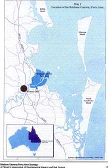
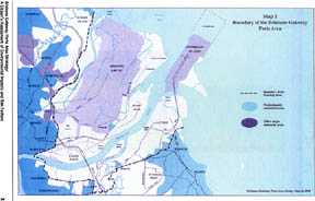
The Brisbane Gateway Ports Area Strategy (Maunsell Pty LTD 1998) has been developed to maximise the economic potential of the Brisbane Gateway Ports Area (BGPA). This area encompasses the operations of the Port of Brisbane Corporation (PBC), the Brisbane Airport Corporation Limited (BACL) and land development close to, and adjacent to, these two ports. Map 1 identifies this area which has significant environmental value. Map 2 shows more precisely the boundary of the BGPA. As the maps show, the BGPA is located on and near the mouth of the Brisbane River which flows into Moreton Bay/Quandamooka. (Quandamooka is the Indigenous name for the Moreton Bay area). The operations of both the PBC and the BACL extend into the bay area. Further, the BGPA is adjacent to, and encroaches upon, a wetlands area of international importance which is listed under the RAMSAR Convention — an international treaty aimed at the protection and sustainable use of important wetlands.
Both the development of the PBC and the BACL have, to date, impacted significantly on this environment. Proposed future developments suggest more disturbance of this natural environment. The intent of this report is to explore the past and future development in the BGPA and to identify and begin to assess environmental impacts and risk factors which threaten the ecological integrity of this valuable environmental location, especially the estuarine and marine areas in and adjacent to it. This is not an exhaustive report and some environmental impacts such as air and noise pollution are only alluded to. This is not to deny the significance of these threats to the natural and social environments in the BGPA.
Overall, the report will take shape in four parts:
a
brief conclusion.
2. FOCUS ON THE PORT OF BRISBANE CORPORATION
2.1 Background to and Rationale for the Proposed Extension of the Fisherman Islands Precinct, Port of Brisbane Corporation
2.1.1 The Limits of the Port of Brisbane Corporation
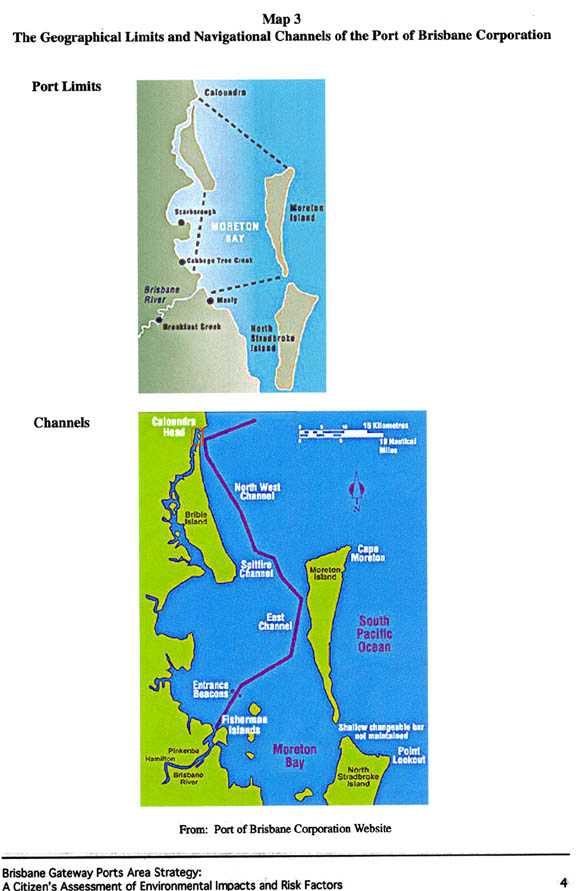
The main operations of the PBC are situated within the natural boundaries of Moreton Bay/ Quandamooka and the Brisbane River estuary. There are two main zones in Moreton Bay/ Quandamooka — (i) an inshore littoral zone, running alongside the mainland, which is dominated by estuaries; and (ii) an eastern zone which is dominated by the ocean (Davie 1998, p. xvii). The limits of the PBC cross both zones, extending from Caloundra to the southern tip of Moreton Island. Navigational channels provide access to PBC facilities at the FI precinct, located on the inshore zone near the mouth of the Brisbane River, and upstream of the river estuary to facilities situated at the Hamilton precinct. Map 3 shows the limits and the navigational channels of the PBC in relation to the marine environment of Moreton Bay/Quandamooka.
Moreton Bay/Quandamooka is a designated marine park (Queensland Department of Environment and Heritage 1993) although the operations of the PBC are not governed by the State’s marine park legislation. It operates under separate State legislation.
2.1.2 The Economic and Trade Imperative
The PBC operates the third largest container port in Australia, handling mixed general and bulk cargo. In 1997-98 total trade and container traffic of the PBC was close to 20.5 million tonnes, a small increase of 1.1% on the 1996-97 figure. Further, the PBC registered a record operating revenue of $78 million for the same period (Annual Report 1997-98). A competitive advantage held by the PBC is that its facilities are located just 10-12 sailing days from major Asian centres such as Singapore, Japan and Hong Kong.
In the last twenty years, $400 million has been invested in the Port of Brisbane to create a deep-water seaport with modern container terminals and bulk cargo facilities. Major development was initiated in 1976 with the establishment of the Port of Brisbane Authority (PBA) which was charged with the task of building new port facilities at FI. In 1994 the Authority was corporatised and a new era, based on a competitive, commercial outlook, began. Now, in this new era, the future of the PBC is increasingly linked to developments planned by the BACL. Together, the airport and seaport have formed a strategic alliance to optimise economic and trade development in South East Queensland. The Brisbane Gateway Ports Area Strategy (Maunsell Pty LTD 1998) referred to earlier is the blueprint for future synergetic development of the PBC and the BACL. In this document, the PBC, as part of an integrated air and sea transport hub, is poised to become part of a major international trade port rivaling Singapore and Rotterdam.
It is in this context that the ongoing development of the PBC and, in particular, of the extension of facilities at the FI precinct, is proposed.
2.1.3 The Fisherman Islands (FI) Precinct
In recent decades the FI precinct has become the ‘hub’ of PBC activity with the construction of wharfage areas, intermodal facilities and commercial outlets. It is planned that this will continue and be extended. This is driven by two factors. Firstly, the relocation of port facilities from ‘up river’ Hamilton to the FI precinct is gaining momentum as the demand for prime, riverside real estate development accelerates in Brisbane. The transformation of the old Newstead and Teneriffe wharves is a precursor for what is likely to follow in the Hamilton precinct if PBC facilities are relocated or significantly downsized there.
The main driver for the FI expansion, however, is the need to be able to cater for larger vessels, with drafts of at least 10 metres, in the future or lose trade to other competitors. Currently, port sites upstream from the mouth of the Brisbane River are constrained by a depth of 9.1 metres. In contrast, the FI berths and the port channels are maintained at around 13.5 metres. Further, the cost of deepening upstream river channels is prohibitive. The PBC estimates the cost of deepening the Lytton Rocks stretch of the Brisbane River by one metre alone as $100 million. In contrast, deepening existing berths at FI and the bay channels is far less prohibitive at $4 million annually (Port of Brisbane Corporation 1998 b, p. 3).
Maintaining adequate water depth cost-effectively, therefore, is the primary determinant for the expansion of the FI precinct.
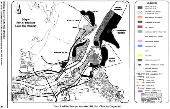
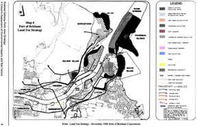
How, then, is this expansion of FI to take shape? Map 4 provides a snapshot of the planned integrated land use for the PBC and identifies the area of future extension of the FI precinct (Port of Brisbane Corporation 1998 a). Approval is being sought for the reclamation of approximately 270 hectares of land for this extension. This will add to the current 425 hectares already reclaimed or in process of being reclaimed at FI at present. This major development will involve:
The PBC estimates that 17.5 million cubic metres of fill will be needed to reclaim the extension area. It is expected that this will come mainly from routine dredging of navigational channels in Moreton Bay/Quandamooka and from that required to create additional shipping berths at FI (Port of Brisbane Corporation 1998 b, p. 2).
2.1.4 The Significance of the Geographical Location of the Port of Brisbane
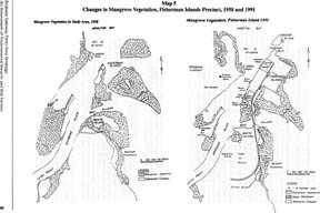
The PBC has elected to situate its major activities at the mouth of the Brisbane River, in a delta-like, intertidal estuary environment adjacent to an internationally designated wetland site (RAMSAR 1971). The reclaimed FI precinct originally consisted of several small islands, largely saltmarsh/claypan areas, before siltation and mangrove growth linked them. Mangrove forests and seagrass meadows in this intertidal area have been, and remain, significant to marine and estuarine ecosystems (Chenoweth & Associates Pty LTD 1992, p. 18), particularly as roosting habitat for migratory wading birds and as food sources and nurseries for marine fauna such as dugong, turtles and fish populations. This natural environment has been transformed by recent port developments undertaken prior to the establishment of a single port authority in 1976 and after. Map 5 illustrates the transformation that has taken place between 1958 and 1991.
The location of the PBC and the proposed development of the FI precinct are consistent with what has been, over a 150 year period, dramatic human interventions in the marine environment of Moreton Bay/Quandamooka and the lower reaches of the Brisbane River. An understanding of this provides an important context for assessing the likely impacts of the proposed FI precinct expansion. It sets a context for making judgements about how cumulative artificial disturbances have impacted on the biological resources of this marine environment and how much more they can withstand before the chronic loss of ecological integrity reaches a point of no return.
2.2 An Historical Overview of Artificial Disturbances and Environmental Risk Factors Related to the Development of the Port of Brisbane, 1860s - 1990s
2.2.1 Port-related Disturbances and Risk Factors
With the arrival of Europeans to Moreton Bay/Quandamooka the waterways were seen as major assets for commerce and industry. However, the lower reaches of the Brisbane River and parts of the bay were shallow and this impeded the movement of trading ships. In fact, two bars were situated at the mouth of the Brisbane River:
an inner bar stretched northeast from Luggage Point near the mouth of the River and an outer bar, about 1.6 kilometres wide, stretched across the River entrance (Gregory 1996, p. 38).
Initially, these bars forced large ships to moor in Moreton Bay/Quandamooka and move goods upstream in smaller vessels. This posed hazards for shipping and for some, notably pastoralists on the Darling Downs, Brisbane was seen as an unsatisfactory location for a seaport for this reason. Ipswich on the Bremer River was preferred with a link built to a seaport in Moreton Bay. Politically, Brisbane remained the desirable location for the seaport and, within a short time, the Queensland Government took the initiative and began a programme of dredging and modification of the Brisbane River to ensure its suitability for shipping (Gregory, p. 41).
The natural course of the Brisbane River was altered considerably as a result. The bars were dredged, cut away and deepened, navigational channels upstream to the City precinct were created and whole sections of land were removed from the banks of the river to widen it. For example, more than ten acres was removed from Gardens Point to improve navigation (Gregory, pp. 38 - 48). Not only did the dredging, blasting and damming impact on the Brisbane River and its ecosystems but the dredged spoil, which has to be dumped somewhere, also changed the riverscape and intruded into Moreton Bay/Quandamooka. Initially spoil was dumped behind Parker Island Reach near Eagle Farm but, as this filled up, the spoil was dumped at Mud Island and has continued to be dumped there and in other parts of Moreton Bay/Quandamooka.
Mud Island is located in Moreton Bay/Quandamooka just north of St Helena Island, west of the FI precinct and east of the southern end of Moreton Island.
Despite criticism of the selection of this waterway as a major seaport site (Gregory 1996), the human interventions which began in the 1860s to impose suitable navigation conditions on the river and the bay have continued to this day.
The PBC continues a major programme of dredging navigational channels in Moreton Bay/Quandamooka and in the Brisbane River for the same reasons as those used in the 1860s — to keep shipping lanes at a safe navigable depth. Recent estimates prepared for the PBC (WBM Oceanics Australia 1997, pp. 13 - 14) reveal that, in 1984, 2,546,000 cubic metres of spoil were dredged and relocated at Mud Island in the bay. Since 1990, because what is suitable for reclamation purposes has been used at the FI precinct, the volume of spoil needing to be dumped has reduced significantly. If the proposed extension to FI proceeds, it is expected that dredged spoil will continue to be used for reclamation, thus alleviating the immediate need to find suitable placement for such a huge volume of spoil.
Nonetheless, while this may take the pressure off the PBC for the present, the placement of dredged spoil remains problematic. The same report (1997, pp. 14 - 15) projects that, on current volumes of dredged spoil from navigational channels, Mud Island will be fully utilised as a dumping site by 2004, even sooner if the FI precinct ceases to take the dredged spoil for reclamation. Further, the relocation of a Material Placement Area (MPA) somewhere else in Moreton Bay/Quandamooka is likely to meet with resistance from environmental groups.
In summary, dredging and dumping of spoil have been a feature of seaport activity in Brisbane for nearly 130 years and will continue for years to come as this marine environment continues to be moulded into a deepwater facility.
Other port-related activities have also, over time, altered the ecological integrity of this marine environment and these also continue to pose an ongoing risk to the marine environment. These include (Moreton Bay Catchment Water Quality Management Strategy 1998, pp. 72 - 75):
Clearly, the expansion of the FI precinct will be another artificial disturbance in Moreton Bay/ Quandamooka in what, since the 1860s, has been a massive effort by human beings to mould an unsuitable natural environment into a modern intermodal port facility of international standing. The proposed development will inevitably impact on the marine environment and this will be considered in detail in section 2.3 below. At this point it is posited that the impacts of the FI precinct expansion will be part of a series of cumulative impacts which have already altered this marine environment. Further, the expansion will consolidate the PBC, thus ensuring that environmental risk factors, germane to the maritime industry, will continue in Moreton Bay/ Quandamooka. This makes the implementation of effective environmental management regimes a matter of top priority.
2.3 Impacts of the Proposed Extension of Fisherman Islands on the Marine Environment of Moreton Bay/Quandamooka
So far this project has (i) outlined the scope of the proposed expansion of the PBC at the FI precinct and discussed the rationale for it; and (ii) located this development in an historical context of cumulative artificial disturbances and the real and probable environmental risks posed by the ongoing operations of the PBC on the natural environment. This establishes a framework for canvassing specific impacts of the proposed development on the marine environment in Moreton Bay/Quandamooka. This next step will include:
2.3.1 Navigational Dredging and Spoil Disposal
Turbidity is a natural phenomenon which results from suspended sediments carried along by tidal currents in waterways, preventing them from settling to the bottom of the river or seabed. This is a natural feature of waterways but when artificial disturbances come into play the balance can be altered significantly. The Moreton Bay Catchment Water Quality Management Strategy (MBCWQMS) claims that the Brisbane River estuary is now the most turbid of all subtropical estuaries in Australia with increased levels of sedimentation and sediment suspension (1998 a, p. 113). One indicator of the impact of increased sedimentation in the offshore zone of Moreton Bay/Quandamooka is the thick muddy deposits found around mainland beaches. It is recorded that many people still recall the sandy beaches at Wynnum.
Recent studies, including the 1997 Brisbane River and Moreton Bay Wastewater Management Study (BR&MBWMS), have identified navigational dredging and spoil deposits as contributing factors in increased sedimentation and accompanying sediment suspension in this estuarine zone and marine environment. Other contributing factors include the impact of extractive industries operating in waterways, rural and urban stormwater run-off and reduced river flows resulting from dams and weirs.
Navigational dredging specifically contributes to the suspension and re-suspension of sediments. Dredging and related activities which have, over time, created these conditions are identified as (MBCWQMS 1998 a, pp. 112 - 113; BR&MBWMS 1997, p. 2):
The most turbid part of the Brisbane River estuary is the middle section, from New Farm to Moggill. However, the lower estuary is not immune from increasing turbidity even though the impact of currents from Moreton Bay/Quandamooka have the effect of making estuarine waters clearer. In short, increased turbidity is a problem wherever navigational dredging occurs in this marine environment (Davie 1998, p. xx).
The BR&MBWMS sums up the interconnected effects of increased suspended sediments on marine environments:
Increased levels of suspended sediments reduce the clarity of the waterways and the Bay. Not only does this make the water look less attractive, but it significantly reduces the amount of light able to reach the river beds and shallow bay bottom. Without adequate light, plants such as the water plants of the river and the seagrasses of the bay are unable to photosynthesise. Habitat important to a range of fish and invertebrate species is lost as a result. Biological diversity is reduced, the food chain is broken, potentially threatening already endangered species including the dugong and green turtle, and recreational and commercial fish catches decline (1997, p. 3).
This, combined with the release of pollutants and nutrients from sources such as sewage outlets at Luggage Point and Tingalpa Creek, constitutes a significant threat to the marine ecosystem.
Dredging and spoil disposal can also have adverse effects on the seabed and its inhabitants. While strategies have been devised to minimise seabed effects (Chenoweth & Associates Pty LTD 1992, p. 19), dredging is a recurrent artificial disturbance on benthic organisms and the recovery of these populations can be slow. Spoil disposal further threatens benthic populations, smothering habitats and introducing pollutants into disposal areas.
Obviously, navigational dredging and spoil disposal will continue as part of the operations of the PBC. It is required under law to ensure adequate channel depth for shipping and, as noted, this is essential if the PBC is to achieve its objective of becoming an international intermodal transport hub. Notwithstanding this, the proposed expansion of the FI precinct heralds both good and bad news in terms of navigational dredging impacts. If facilities at the Hamilton precinct are gradually transferred to the FI precinct, as ships and liners get larger in size, then navigational dredging upstream of the Brisbane River is likely to cease sometime in the future. This will remove one artificial source of turbidity in the estuary. However, the proposed expansion will involve berth dredging at FI, contributing to further sediment suspension which, in turn, could be threatening to seagrass meadows close to the expansion site.
A short-term benefit which would flow from the FI development is that dredged spoil will be used for reclamation purposes, alleviating the immediate need to find other MPAs in the bay. This provides the PBC with time to explore options for improved dredging and dredged material management (Interagency Working Group on the Dredging Process 1994). However, this benefit could be neutralised if the demand for large volumes of fill for the port extension also required large scale extraction of the marine fine sand resources of Moreton Bay/Quandamooka (Department of Mines and Energy 1999, pp. 12 and 14). This would simply shift the environmental impacts around.
2.3.2 Mangrove Forests, Saltmarshes and Seagrass Meadows and Links with the Food Chain and Habitat
Mangrove forests and seagrass meadows, along with saltmarshes, are plant communities located in and influenced by tidal action. They play a highly productive role in estuarine ecosystems. A WBM Study (1992 b, p. 36) identifies their productivity as providing:
The distribution of these plant communities is governed by a complex interaction of physical and chemical factors. Mangrove distribution is influenced by such factors as tidal levels, soil types, salinity and drainage. Seagrass distribution is determined especially by the availability of light penetration which enables the plant to photosynthesise and reproduce. Sediment levels obviously impact on this.
The BR&MBWMS (1997 a, p. 3) has noted the historical changes in the distribution of mangrove and seagrass within Moreton Bay/Quandamooka. Comparative data exists to the late 1980s and what this reveals is that from 1974 to 1987 mangrove forests declined across the whole bay by 8%. Saltmarsh/claypan reduced by 17%. This decline was the result of land clearing in places such as Raby Bay and the degradation caused by other human activities. However, this Study also noted the resilience of some mangrove communities which may have actually increased because human activity had extended the habitat areas by bringing more fine sediment to the onshore areas of the bay. Overall, seagrass meadows have not fared as well. In fact, the loss of seagrass is a key indicator of the decline of the health of marine ecosystems in the sub-regions of Bramble Bay and Deception Bay. The MBCWQMS (1998 a) attributes the decline in seagrass meadows to sediment from stormwater run-off and the re-suspension of mud from the middle of the bay — the latter being a likely outcome of navigational dredging.
As noted previously, the FI precinct once consisted of several small saltmarsh and claypan islands surrounded, and linked in part, by mangroves. Several hundred hectares of seagrass grew in shallow, intertidal mudflat waters. The transformation of FI into a seaport facility has seen the reduction of these plant communities. Map 5 illustrates this in relation to mangrove and saltmarsh vegetation.
In 1992 Chenoweth & Associates Pty LTD (Table 3: Sites of Conservation Significance) identified 250 hectares of mangroves, saltmarshes and seagrass at the southeastern side of the FI precinct, adjacent to Whyte Island, as an area of high international and national ecological significance (pp. 16 and 18). Map 4 shows the location of this area of high ecological value. In particular, it provides habitat for rare and endangered bird species and is used by migratory wading birds covered by international agreements. The PBC’s recently released Land Use Strategy (1998, pp. 8 - 9) has reaffirmed the environmental significance of this area and, while there is no intention on the part of the PBC to disturb this, its proximity to the proposed extension is of concern. In particular, increased turbidity during the reclamation of the area could impact on seagrass meadows, putting them at risk and possibly reducing these in the inshore zone of the bay. WBM (1992 a, p. 181) refers to an unconfirmed claim of spoil overflow at the FI precinct in the mid-1980s. Fishermen claimed this reduced fish catches for over three years, until the seagrass recovered. It is not beyond the realms of possibility that such a scenario could occur and have consequences for this significant site at the south-east of the precinct.
FI and other parts of the intertidal wetland area of Moreton Bay/Quandamooka have been significant habitat sites for many bird species, local and migratory. However, in recent years there has been significant loss of roosting habitat as a result of foreshore residential development and that associated with the seaport and airport. Disturbance has been considerable. Large, important roosting sites have either been fragmented (Driscoll 1992) or lost altogether. In response, artificial roosts are being constructed to replace some that have been lost to developments such as Raby Bay (Baycare News 1998, p. 12).
In recent years, the PBC has monitored bird numbers and habitat conditions at the FI precinct (Driscoll 1992 & 1998). This exercise has affirmed the importance of FI as a bird habitat. Driscoll (1998) notes that:
roost sites on Fisherman Islands are important because they serve at least three groups of species with different foraging strategies and preferences for a range of feeding substrates which can be found within a 10 km radius;
and
parts of Fisherman Islands (provide) the means of facilitating the use by birds of neighbouring intertidal areas where the birdlife is a significant component of local ecosystems (p. 63).
Given this significance, it is imperative that the proposed development of the FI precinct does not diminish this bird habitat in any way. The preservation of intertidal mangroves and saltmarsh is a critical part of ensuring this.
2.3.3 Fisheries
The estuaries, mangroves, seagrass and mudflats of Moreton Bay/Quandamooka are the nurseries of many fish species as well as prawns, crabs and other seafood consumed by the human population. The productivity of this fishery is illustrated by Davie (1998, p. xx):
Notwithstanding this productivity, one environmental warning sign in the bay is the decreasing number of fish (MBCWQMS 1998 a, p. 88). Among the reasons for this is the loss of mangrove and seagrass nurseries which provide primary food sources for aquatic organisms. This highlights the interconnectedness within the marine environment and the flow-on effects of disturbances through ecosystems.
Section 2.3.2 referred to the ecological significance of the mangrove/seagrass site southeast of the FI precinct. This area is noted as an important fishery nursery and feeding habitat (WBM 1992 a, p. 173). The risk to this area of spoil overflow and increased turbidity has been canvassed. Further, while vegetated habitats are vital, unvegetated habitats are also important for fisheries. The proposed FI extension will reclaim approximately 270 hectares of unvegetated habitat, erasing benthic communities which are also important in the marine food chain. This, combined with what has already been reclaimed with earlier FI development, represents a significant loss of intertidal fisheries habitat in this part of Moreton Bay/Quandamooka.
2.3.4 Summary Comment
The operations of the PBC are not the only human interventions to impact on Moreton Bay/ Quandamooka. Sewage flows, sediment run-off from urban and rural development, recreational boating and fishing, and tourism have all combined to constitute a major threat to this marine environment. However, the PBC and its precursors have been a significant artificial disturbance because their interventions have radically altered the river mouth and estuary and those parts of the bay dedicated to navigational dredging and spoil disposal. The extension of the FI precinct is a continuation of these radical interventions.
The question remains as to how long the marine environment can sustain this cumulative human intervention and still retain its ecological integrity. This is a difficult question to answer. However, there is a growing recognition by various levels of government, the scientific community, industry and local communities that Moreton Bay/Quandamooka and its catchment are at serious risk from human exploitation, that resilience is low in some parts and that unsustainable use of this unique biological resource cannot continue. It is noteworthy that the main hub of the PBC sits midway between Bramble Bay and Waterloo Bay — two sub-regions of Moreton Bay/ Quandamooka which report serious environmental problems (MBCWQMS 1998 b). The warning signs are there to be heeded by the PBC and other key stakeholders.
2.4 The Relationship of the Port of Brisbane Corporation with Other Stakeholders in Moreton Bay/Quandamooka
The PBC cannot operate in isolation from the interests of other stakeholders. So far the Corporation has demonstrated a willingness to play its part in an integrated environmental management regime (MBCWQMS 1998 a). Further, it has developed consultative structures to allow for the participation of stakeholders and to hear stakeholder perspectives. In the end however, the question is how far the PBC will go to accommodate stakeholder requests if these impede its perceived economic viability. Key objectives of the PBC are to remain economically competitive and to become an intermodal port of significance in the region and beyond. The extension of the FI precinct is germane to this. The PBC does not have much room to manoeuvre.
In gathering data for this report a number of conversations were held with stakeholders. One conversation was instructive. A public servant scientist noted the risk posed by reclamation of intertidal areas to fisheries and said that the department opposed more of this intervention on environmental grounds. The conversation concluded with:
In the end this (the reclamation for the FI precinct extension) will be a ‘whole of government’ decision and I don’t expect what we say will stop anything!
2.5 Concluding Comments
The decision last century to establish a seaport in relatively shallow waters was a triumph of politics and economics over any environmental concerns for the estuarine and marine ecosystems in which the seaport was to be situated. This became the decision-making blueprint for further development of seaport facilities in Brisbane. At the time, this decision was fully consistent with the ‘frontier’ attitude that was in the process of transforming much of this continent (Kirkpatrick 1994). The biological resources of this waterway were there to be exploited rather than to be managed sustainably.
This decision was problematic from the start. It locked future generations into a commitment which required ongoing human interventions, some quite radical, in the river estuary and bay to mould the waterway into a functioning and economically viable operation. This has impacted significantly on many aspects of the estuarine and marine environment. The proposed extension of the FI precinct is just one intervention in a series of cumulative artificial disturbances which began in the 1860s. As section 2.3 has demonstrated, the development will further impact on biological resources — in the short-term and in the long-term. While it will relocate PBC operations from the Brisbane River estuary, it will consolidate the PBC in Moreton Bay/Quandamooka and keep in place risk factors which will actually and potentially continue to impact upon the biological resources of this marine area.
Notwithstanding this, it is acknowledged that the PBC and other relevant authorities and stakeholders are adopting an integrated environmental management regime to minimise the worst impacts of future use of this waterway and redress some of the degradation already caused (Brisbane River Management Group 1998). As part of this, the PBC is committed:
In addition, environmental standards are being applied in important ‘risk’ areas. For example, management actions being proposed by the MBCWQMS (1998 a, pp. 72 - 75) for boats, ships and associated activities include:
These management actions, many upheld by government legislation and international protocols, will go some way towards minimising impacts of PBC operations on biological resources. However, it is desirable that such initiatives be made mandatory rather than voluntary in order to maximise effectiveness. It is also imperative that an effective monitoring regime be established to ensure the effectiveness of environmental management regimes.
Overall, Moreton Bay/Quandamooka and its catchment have exhibited remarkable resilience to the pressures of human activity, especially since the 1860s. While there is a marked contrast in areas of the bay itself, the system as a whole is still intact (MBCWQMS 1998 b, p. 67). Still, there are areas of the bay which are at the crossroads, some of which are in close proximity to the PBC — Bramble Bay, Waterloo Bay and at the mouth of the Brisbane River. Given this, it is imperative that further environmental degradation be avoided by port operations and that effective strategies be employed by the PBC to conserve the ecological integrity of this marine park.
On balance, it would appear that the PBC will remain, with
others, a significant stakeholder in accessing and using the biological resources
of Moreton Bay/Quandamooka — at least well into the next century. It is
unrealistic politically to think otherwise as the PBC is perceived to be a key
economic driver for development in South East Queensland (Maunsell Pty LTD 1998).
A
great deal of faith is being placed on environmental management regimes to minimise
adverse effects of PBC operations on the estuarine and marine environments.
With the best mitigation strategies in place, it is hoped that the environmental
value of Moreton Bay/Quandamooka will be preserved. Of course, in the long-term,
it may be that the knowledge base on which human interventions are currently
assessed will be proven to have been inadequate. That is the overall risk posed
by such interventions. Will the seventh generation thank this generation for
its stewardship of this ecosystem?
3. FOCUS ON THE BRISBANE AIRPORT CORPORATION LIMITED
3.1 Background to the Brisbane Airport Corporation Limited (BACL)
3.1.1 The Limits of the BACL and the Environmental Significance of the Site
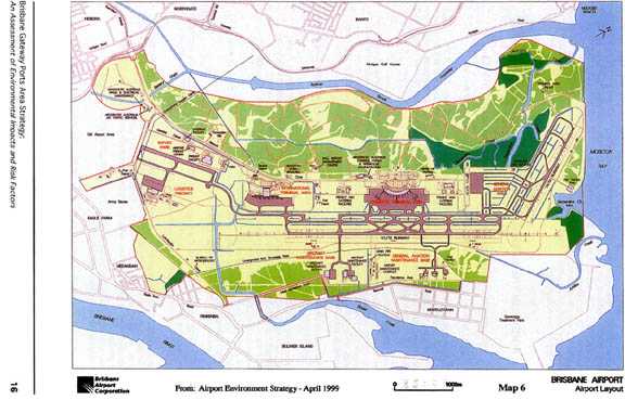
The Brisbane Airport was relocated from Eagle Farm to the present location in 1988. Map 6 shows the layout of the existing airport and its proximity to the old airport area at Eagle Farm. This move followed the recognition in the early 1970s that air traffic in Brisbane would soon exceed the capacity of the existing airport facilities and that a new site was needed. From many perspectives, the new site was ideal:
Notwithstanding these benefits, the move to the northeast of Eagle Farm relocated Brisbane Airport into an area of ecological significance. For example:
As with the PBC, the development of a major airport on this site required extensive modification and disturbance of the natural environment so that, now, little of the 2,700 ha remains in its original condition. For example, the development of this airport site has involved:
This is not the end of the development story for the BACL. The BACL has developed a master plan (BACL 1998) outlining its proposed development agenda until 2018.
More extensive development is planned, especially the development of a new runway (01L /19R), the extension of the second existing smaller runway (14/32), the development of industrial parks, commercial and retail precincts and connecting transport infrastructure.
3.1.2 The Economic Imperative
Australia has been at the forefront of air transport this century. We have high rates of air travel and have come to rely on this form of transport to overcome the ‘tyranny of distance’ both within Australia and in relation to the rest of the world. From an infrequent destination after World War II, serviced by a small aerodrome facility at Eagle Farm, the Brisbane Airport is now a destination for a growing number of domestic and international visitors. Further, as the economy of South East Queensland (SEQ) continues to grow in an increasingly globalised economy, the Brisbane Airport’s contribution to this is recognised as significant and invaluable. The 1996 estimate of SEQ exports was $17 billion and imports were $20.5 billion and growing with a significant proportion of traded goods and services utilising the airport facilities.
At a State level, the BACL’s Master Plan 1998 has quantified the contribution made by the Brisbane Airport to the economy of Queensland. In 1996/97 the Brisbane Airport accounted for 6.8% of Gross State Product and generated 5.2% of employment (1998 p. 9).
Further, considering each Boeing 747 landing and taking off from the Brisbane Airport in 1996/97, the document claims the following economic benefits are generated (1998 p. 36):
Given that there were 131,000 regular passenger transport (RPT) movements in 1997, these cumulative economic flow-ons are significant. By 2018 it is estimated that total RPT movements will increase to 329,000 per annum with consequent flow-on effects for the State economy.
The RPT movements underscore the fact that total transport movements at the Brisbane Airport have tripled in the past twenty years. By 2018 it is anticipated that total passenger traffic will be 33 million passengers per annum compared to 10.6 million in 1996/97.
Domestic and international airfreight also continues to grow at a significant rate.
3.1.3 Ownership
Until recently, Australia’s major airports were owned and operated by the Commonwealth Government. In late 1987 the Federal Airport Corporation (FAC) was created as a Government Owned Enterprise with a mandate to operate commercially. In 1996, the Commonwealth passed legislation to enable the privatisation of airports which it owned. The long-term lease on the Brisbane Airport was subsequently purchased by BACL which took over the management and operations in July 1997. The main stakeholders in the BACL are:
With privatisation, the BACL is poised to enter into a new phase of development which its advertising describes as moving from being a city airport to being an airport city. It has sound financial backing and can draw on the international management expertise of Amsterdam Airport Schiphol.
3.2 The Runway Developments
3.2.1 An Overview of Runway Plans
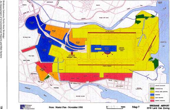
The BACL Master Plan 1998 outlines the proposed developments leading towards 2018. Map 7 provides a snapshot of the land use proposals. It shows clearly the various types of development being considered, including the proposed runway developments, that is, the new runway (01L/19R) referred to as the western parallel runway, and the extension of the existing cross runway (14/32) into Moreton Bay/Quandamooka.
The BACL has indicated that the new western parallel runway, of a length of 3,050 metres, will be built and operational by 2018. A provision to increase the length of this runway to 3,600 metres after 2018 is also envisaged. The existing cross runway caters for smaller craft up to the size of a B737 and will be retained with the option to extend it not being proposed until after 2018.
Apart from the proposal to build a rail link to the airport, the new parallel western runway is the airport development most familiar to the general public. The reason for this is obvious. Air traffic contributes to noise pollution and no one wants a flight path over their property. This is a ‘hot’ political issue in Brisbane as it has been and continues to be in other cities, with Sydney as the classic example. The BACL’s plan for a new parallel western runway to accommodate the volume of air traffic expected in the next twenty years has not had an easy run — it brings into relief a combination of environmental and social impacts which tend to generate strong community opposition.
3.2.2 Community Protest
The protest about the new parallel western runway has been very vocal and highly politicised.
Public reaction prompted a response from the BACL Board. On 1 August 1999, prior to the Senate’s initiative, the BACL publicly announced that the runway plan in the Master Plan 1998 was to be altered to accommodate community concerns about noise. The accommodation meant that the runway would go ahead but it would be a staggered runway and it would be moved a further 1.3 kilometres away from homes. The nearest home would now be 6.3 kilometres away from the end of the staggered runway. This would have the effect of moving the noise contours towards Moreton Bay/Quandamooka and away from the City. This announcement also included that work on the parallel staggered runway would not commence for at least five years.
Notwithstanding this, the Senate Rural and Regional Affairs and Transport References Committee initiated an inquiry in late August 1999 into the development of the BACL’s Master Plan 1998. The emphasis of this inquiry is on the decision-making process behind the future construction of this runway. The Terms of Reference are attached as Appendix 1 of this report.
Submissions were received and public hearings have been held. At the time of writing the report and conclusions of this inquiry were not available although a Hansard Report of the Brisbane hearings reveals considerable community disquiet, notably about noise and air pollution over Brisbane suburbs.
3.3 Environmental Concerns about the BACL’s Future Development
3.3.1 Overview
The BACL’s Master Plan 1998 identifies that the planned developments will impact on ecosystems in two ways (pp. 84 - 85):
(i) the clearing, earthworks and land reclamation associated with the construction of the new runways, buildings and other facilities;
(ii) operational impacts, particularly water and noise pollution.
In addition to this, the growth of air traffic will contribute to air pollution. A summary of the issues involved here is attached as Appendix 2. This argues that air pollution is likely to accelerate in the Brisbane sub-region from further large-scale airport development. Serious health consequences for the residents of Brisbane are likely to follow.
Another key consideration is the number of contaminated sites within the airport boundary and the possibility of further contamination of soil and waterways through storm water run-off. While this is important and must be factored into cumulative effects on the airport and surrounding environment, the focus of this report is mainly on the environmental impacts of developing the proposed staggered and cross runways as highlighted in (i) above.
(The BACL’s own report Airport Environment Strategy (1999) provides a general overview of environmental issues facing the future development and maintenance of the airport facility into the early part of the new century.)
3.3.2 Key Environmental Impacts of the Runways
Section 2.3.2 of this report discusses the productivity of mangrove communities in relation to estuarine and marine food chains and habitat. This becomes relevant again in this context because the development of this runway will require the removal of remnant mangrove communities as part of the reclamation process. The extent of loss of mangrove communities is outlined as follows.
Correspondence from the BACL about the new runway proposal stated that:
(the original second runway proposal) would have affected 45 hectares of remnant Serpentine Creek (west branch) mangroves but now, with the proposal for a staggered runway located further away from residential areas, an additional 33 hectares of mangroves associated with Jacksons Creek will be impacted.
A total of 78 hectares of mangroves will be impacted under this present proposal as opposed to 45 hectares under the (original) Master Plan option.
The correspondence went on to state that:
In keeping with the notion of no nett loss of mangroves, it is planned to establish around 87 hectares of mangroves in the Jacksons Creek vicinity, a nett gain of around 9 hectares of mangroves.
It is worth keeping in mind that new areas of mangrove establishment can take up to twenty years before they reach the same maturity and value of the mangroves they are replacing!
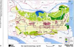
See Map 8 for details of Jacksons Creek and Serpentine Creek in relation to existing vegetation areas located within the airport boundary.
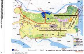
See Map 9 for details of mangrove loss and proposed mangrove establishment from the proposed alternative parallel runway.
The BACL’s own Airport Environment Strategy (1999, pp.17 - 18) noted the very high conservation value of the mangrove communities in the Jacksons Creek-Serpentine Creek area:
Serpentine and Jacksons Creeks supported flourishing and diverse invertebrate and fin fish communities prior to the construction of the airport ... whilst the extent of Serpentine Creek has been significantly reduced through the development of the airport, from observations of current habitat, it is highly likely that these creeks and the adjoining engineered channels continue to support significant communities of these and other species. These subsequently migrate to the open waters of Moreton Bay.
So, the plan to move the second parallel runway further from residential areas will have an impact on important remnant mangrove communities.
As outlined at present, the cross runway will also require reclamation work but, in this case, this will involve over 60 hectares of intertidal soft sediment in Moreton Bay/Quandamooka, adjacent to Nudgee Beach (see Map 7 Land Use Zoning). The reclamation being proposed will be a major disturbance on the ecosystem of these intertidal flats.
The intertidal mudflat habitat is an exceptionally open system, both physically and biologically. The ecosystem is a habitat for many organisms and is influenced very much by the tides. It is a feeding ground for many species, depending on whether it is low or high tide. For example, at low tide, gleaning and probing shorebirds feed on and in the exposed surface while waders seek prey stranded in tidal pools.
Of particular concern is that the disturbance of this area may impact negatively on beach nesting species of birds such as the beach thick knee and the little tern which are listed as ‘vulnerable’ by the State of Queensland and which could become endangered if threats to habitat continue. The loss of roosting sites is another consideration. The latter point has been discussed in relation to the PBC development at Fisherman Islands in section 2.3.2.
Overall, nutrients, organic particles and living organisms move in and out of the habitat. The sediments of mudflats also serve as a nutrient sink. Intertidal mudflats are a critical part of the estuarine and marine environment.
3.4 Concluding Comments
Even with a brief overview, it is evident that the runways development will involve further modification of the airport site and be a significant disturbance factor on ecosystems within it. While it may absorb a large proportion of spoil from PBC dredging and partly resolve a problem there, the use of this for more reclamation of sensitive delta land simply shifts an environmental problem around. Chenoweth & Associates Pty LTD (1992, p. 28) have noted the risk to the estuarine and marine environments of possible contaminated dredged fill. This report stated:
Estuarine sediments near the river mouth are known to have high levels of a range of toxic pollutants, and disturbance by dredging may release these into the marine ecosystem. In addition, the use of dredged material for reclamation may transfer contamination to land sites ... responsibility for pre-dredging analysis, impact assessment and notification have not yet been clarified.
Progress may have been made on this since 1992. However, it remains an important issue in the ongoing development of the BGPA.
As with the PBC, the BACL has developed environmental management regimes to mitigate the negative impacts of the proposed development. For example it proposes that it will:
While this is positive, the question remains as to how much more disturbance this site can accommodate without a further diminishment of ecological integrity. Development continues to encroach on areas of very high environmental value which have flow-on effects into the ecosystem of Moreton Bay/Quandamooka. As noted in the section on the PBC, there is considerable faith and hope placed in environmental management regimes. Only the future will tell if this has been well placed or misplaced.
One final word to add to this section relates to the geographical context in which to consider future development of airport infrastructure. Some argue that decisions made about major airport infrastructure development should be regionally-based, encompassing the whole of South East Queensland rather than just the Capital City, Brisbane. For example, Amberley is seen as a real option for future development of a regional airport. It is argued that this would enhance regional development and, as well, alleviate the environmental impacts and risk factors associated with the existing and planned airport development in the BGPA.
From a number of perspectives, this argument has considerable merit.
4. FOCUS ON LAND AND LAND DEVELOPMENT
4.1 Introduction
The final part of this project considers the environmental issues around land and land development in the BGPA, especially:
4.2 The Current Situation
At present the BGPA is dominated by the PBC, the BACL and a number of major industrial sites which include:
So far, apart from the BACL and PBC operations, the BGPA has been generally restricted to heavy/noxious industrial development. However, there is currently 2,300 hectares of land which is deemed as having development potential and this development is being pursued intentionally in the Brisbane Gateway Ports Area Strategy (Maunsell Pty LTD 1998, pp. 6 - 7). Table 1 provides a list of sites and area size currently available for development within the BGPA. Most of this land is owned by governments although some is held in private hands.
4.3 Hazardous Industries and Contaminated Sites
When all is considered, the BGPA is a high risk, hazardous environment. It is a site for potential major accidents — oil and other bulk cargo spills, chemical fires, plane crashes, aircraft fuel dumping over Moreton Bay/Quandamooka, nuclear accidents from nuclear warships, and chemical pollution of air and waterways.
Obviously, in an area that includes major industry, it is not surprising that there are a number of contaminated sites in the BGPA, the result of unregulated land use in the past. The risk posed by this extends to both above and below ground, with the latter especially involving underground water contamination. The law now requires that industry adhere to risk management policies and procedures to limit the probability of serious industrial accidents. Notwithstanding this, there are no fail-safe guarantees and the risk of major accidents and consequent contamination of land, waterways and air remain real and probable.
Table 1: Potential Development Areas
|
Location |
Area x hectare |
|
Luggage Point |
80 |
|
Myrtletown |
217 |
|
Boggy Creek |
157 |
|
Bulwer Island |
74 |
|
Pinkenba |
211 |
|
Airport |
515 |
|
Eagle Farm East |
53 |
|
Eagle Farm West |
17 |
|
Fisherman Islands |
368 |
|
Lytton |
212 |
|
Hemmant |
119 |
|
Murarrie |
140 |
|
Queensport |
100 |
|
Colmslie |
38 |
Adapted from Brisbane Gateway Ports Area Strategy (Maunsell Pty LTD 1998)
4.4 Plans of Greater Commercial and Industrial Development
As noted in section 4.2, the potential land development in the BGPA is a key element in the overall development of this economically strategic area. Specifically, the Brisbane Gateway Ports Area Strategy (Maunsell Pty LTD 1998) has identified fourteen potential development areas which encompass light to general industry and commercial activities (see Table 1). Some of these proposed areas are environmentally sensitive. For example, one site deemed suitable for industry around Luggage Point includes extensive saltpan and saltmarshes. The co-location of industry with this environmentally sensitive area is highly questionable.
These potential development areas encompass the land use strategies of the PBC and the BACL. Both entities plan to integrate more commercial development in with their specific industry planning and development. Figure 1 is a sample of a brochure used in a land sale campaign in the BGPA. It illustrates well the land development promotion which is taking shape there.
4.5 Acid Sulphate Soils (ASS) Contamination
Over the past few years Acid Sulphate Soils (ASS) causing acid runoffs have only come to the attention of the community because of increasing releases of acid into the aquatic and marine environment which have killed many fish. Fish kills and certain types of algal blooms are a possible sign of acid release. ASS have been known to engineers and scientists for many years. Due to changed technology, equipment and the ever money hungry developer or council who insists on converting an inexpensive area of wetland into a multi-million dollar canal housing development, housing development, marina or golf course or farmers extending their farm and provision of services such as sewerage, water, phone, power and gas, are exposing more and more ASS which are degrading or destroying sections of our marine and aquatic environment. (Rivermouth Action Group Inc — website)
This quote highlights the threat of ASS to estuarine and marine environments.
ASS is the common name given to soils which contain iron sulphides. When the sea level rose and inundated land, sulphate in seaweed mixed with land sediments containing iron oxides and organic matter. As a result of the chemical reaction, large quantities of iron sulphides were produced. Now, when exposed to air, these sulphides oxidise and produce sulphuric acid — hence the name acid sulphate soils.
Iron sulphides are contained in a layer of water-logged soil. These iron sulphide layers were originally formed under tidal conditions and so are found in low lying areas near coastlines. The layer can be clay or sand. Water prevents oxidisation. When water is removed the oxidisation occurs and sulphuric acid is created. The soil can neutralise some acid but the rest moves through the soil contaminating soil water, ground water and finally surface water. In general, iron sulphide layers would be found in areas where the surface elevation is less than five metres above the mean sea level.
Scientists have estimated that there are more than two million hectares of ASS in Australia, along the coastline. This would contain one billion tonnes of iron sulphides. One tonne of iron sulphide can produce 1.5 tonnes of sulphuric acid when oxidised.
Iron sulphide layers are found along the coastline of Queensland. It is known that these are found in the area of the BGPA (BACL 1999, p. 46; Maunsell Pty Ltd 1998, p. 9). Clearly, ASS is a matter requiring serious attention if more and more development is to occur in the BGPA because of its proximity to ‘at risk’ estuarine and marine environments. From the research canvassed in the preparation of this report it would appear that not a lot of knowledge exists about this. If such knowledge exists, it is not readily available.
4.6 Concluding Comments
As with the PBC and BACL, land development in the BGPA has already modified the natural environment and been a significant disturbance factor. More of the same can be expected in the future with the development of vacant land and the redevelopment of obsolete industrial sites. This will place stress on the natural environment in a number of significant ways discussed here. Again, the issue is how far this human intervention can go until a point of no return has been reached.
5. CONCLUSION
5.1 Concluding Questions
This report has been a non-expert assessment of the impact of ongoing development on the natural environment in the area designated as the Brisbane Gateway Ports Area (BGPA), the blueprint for which is contained in the Brisbane Gateway Ports Area Strategy (Maunsell Pty LTD 1998). As noted, the BGPA encompasses the mouth of the Brisbane River and a delta-like, low lying area surrounding the mouth which is distinguished by wetlands, saltmarshes, claypans, sedge and mangrove communities. Parts of the BGPA are also located in an intertidal zone which also forms part of, and is adjacent to, Moreton Bay/Quandamooka. Mudflats, tidal marshes, mangroves and seagrass beds are found here and are of high environmental value.
This sensitive natural environment has been modified extensively by human intervention. The development of both the PBC and the BACL in this environment is primarily responsible for the transformation that has occurred there in the past one hundred years. In recent times there has been more concern for the impact of such development on the natural environment than there has been in the past. For example, the recognition of the importance of conserving and protecting wetlands has led to the registration of local wetlands as areas of global significance under the RAMSAR Convention on Wetlands.
Notwithstanding this, the development imperative in this area has not abated. In fact, the area is now the focus of more intensive development planning than ever. Much of this has been outlined in this report. The BGPA is poised to become a major economic zone in South East Queensland, relying significantly on transport synergies, air, sea and land, to enhance trade and commerce.
This assessment raises many questions about the development plans for the BGPA. It is on this note that this report is drawn to a conclusion. Seeking the answers to these questions will constitute the ongoing work of the Eco-justice Praxis Group:
These are key questions to which answers will be sought from the PBC, the BACL and the coalition of government, business and industry groups which are promoting the further development of the BGPA.
Work in Progress
Postscript
Since the completion of the first draft of this report, Moreton Bay/Quandamooka has experienced one of the worst outbreaks of toxic blue-green algae ever recorded. The extent of this outbreak caused great alarm, registering a wake-up call to the human community about the fragility of the estuarine and marine environments of Moreton Bay/Quandamooka.
References and Bibliography
Brisbane Airport Corporation Limited (1999) Airport Environment Strategy.
Brisbane Airport Corporation Limited (1998) Master Plan 1998.
Brisbane River Management Group (1998) 1998 Waterways Management Plan.
Brisbane River and Moreton Bay Wastewater Management Study (1997 a) Plants of Moreton Bay and Its Estuaries Information Sheet — Volume 1, Issue 1, Brisbane.
Brisbane River and Moreton Bay Wastewater Management Study (1997 b) Fish Information Sheet — Volume 1, Issue 1, Brisbane.
Brisbane River and Moreton Bay Wastewater Management Study (1997 c) Sediments Information Sheet — Volume 1, Issue 1, Brisbane.
Brisbane River and Moreton Bay Wastewater Management Study (1997 d) Water Movement and Pollutant Processes in Moreton Bay Information Sheet — Volume 1, Issue 1, Brisbane.
Chenoweth & Associates Pty LTD (1992) Gateway Ports Environmental Index Department of the Premier, Economic and Trade Development, Queensland.
Davie, P. (1998) Wild Guide to Moreton Bay Queensland Museum, Brisbane.
Department of Mines and Energy (1999) Extractive Industry Implementation Program Plan Queensland Government.
Deville, A. & Harding, R. (1997) Applying the Precautionary Principle The Federation Press, Riverwood.
Driscoll, P.V. (1992) Assessment of Bird Populations of the Environs of Fisherman Islands. In: Brisbane’s Port Environmental Study, Volume 1 - Baseline Data, 1991-1992, pp. 137 - 166, Port of Brisbane Authority.
Driscoll, PV (1998) Further Assessment of Bird Numbers, Movements and Habitat Conditions in the Environs of Fisherman Islands Port of Brisbane Corporation.
Environmental Protection Agency (1999) Strategy for the Conservation and Management of Queensland Wetlands Queensland Government.
Gregory, H. (1996) The Brisbane River Story: Meandering Through Time Australian Marine Conservation Society Inc.
Hansard, Australian Senate (1999) Brisbane Airport Corporation Master Plan Rural and Regional Affairs and Transport References Committee, Monday, 15 November in Brisbane.
Inter-agency Working Group on the Dredging Process (1994) The Dredging Process in the United States: An Action Plan for Improvement Federal Department of Transportation, Washington.
Kirkpatrick, J. (1994) A Continent Transformed: Human Impact on the Natural Vegetation of Australia Oxford University Press, Melbourne.
Massachusetts Institute of Technology (1999) Ballast Water Fact Sheet.
Maunsell Pty LTD (1998) Brisbane Gateway Ports Area Strategy Department of Economic Development and Trade, Queensland.
Minjerribah & Moorgumpin Elders (1998) Minjerribah: An Indigenous Story of North Stradbroke Island Queensland.
Moreton Bay Alliance (1998) Baycare News April.
Moreton Bay Catchment Water Quality Management Strategy Team (1998 a) Moreton Bay Catchment Water Quality Management Strategy Brisbane City Council.
Moreton Bay Catchment Water Quality Management Strategy Team (1998 b) The Crew Member’s Guide to the Health of Our Waterways Brisbane City Council.
Port of Brisbane Corporation (1997-98) Annual Report Brisbane.
Port of Brisbane Corporation (1998 a) Land Use Strategy Brisbane.
Port of Brisbane Corporation (1998 b) Initial Advice Statement Reclamation at Fisherman Islands Port of Brisbane Website.
Port of Brisbane Corporation (1998 c) Terms of Reference - Impact Assessment Study for Proposed Reclamation at Fisherman Islands Brisbane.
Queensland Department of Environment and Heritage (1993) Moreton Bay Strategic Plan Queensland.
RAMSAR (1971) Convention on Wetlands of International Importance Especially As Waterfowl Habitat UNESCO.
Recher, H.F. (1996) Ecosystems. In: A Natural Legacy: Ecology in Australia (Second Edition)
(eds. H.F. Recher, D. Lunney & I. Dunn) pp. 31 - 51. A.S. Wilson, Inc.
Steele, J.G. (1984) Aboriginal Pathways in Southeast Queensland and the Richmond River University of Queensland Press.
WBM Oceanics Australia (1997) Investigations of Options For the Placement of Dredged Material at Designated Offshore Placement Areas Brisbane.
WBM Pty LTD (1992 a) Fisheries Adjacent to Fisherman Islands. In: Brisbane’s Port Environmental Study, Volume 1 - Baseline Data 1991-92, pp. 167 - 189, Port of Brisbane Authority.
WBM Pty LTD (1992 b) Fisherman Islands Tidal Wetland Study. In: Brisbane’s Port Environmental Study, Volume 1 - Baseline Data 1991-92, pp. 31 - 61, Port of Brisbane Authority.
The websites of the Port of Brisbane Corporation and the Brisbane Airport Corporation Limited were accessed in the process of this research.
Appendix 1
Senate Rural and Regional Affairs and Transport References Committee
Inquiry Into the Brisbane Airport Corporation Limited
Terms of Reference
To inquire into and report on:
The development of the Brisbane Airport Corporation’s Master Plan for the future construction of a western parallel runway, with particular reference to:
a. whether the Brisbane Airport Corporation (BAC) failed to adequately investigate all runway options, including the adequacy of the BAC’s methodology for evaluating runway options, including the economic, social (for example, comparative numbers of households affected by noise), environmental, public health and public safety impacts of each;
b. whether the BAC failed to release flight path information to the community and, if so, why;
c. the role of Airservices Australia and any conflict of interest which may exist between its BAC consultancy role and its obligation to provide advice to government;
d. the adequacy of public consultation undertaken by the BAC; and
e. why the Minister for Transport and Regional Services (Mr Anderson) proceeded to endorse the BAC Master Plan.
Appendix 2
The Brisbane Airshed and Air Pollution
The airshed of Brisbane is well-known for its high pollution potential. Several key factors contribute to this potential:
Evidently, Brisbane not only suffers from an unfavourable atmospheric environment, but also from a lacking understanding of this airshed and its pollutants. Important environmental reports in the Brisbane Gateway Ports Area (of which the Brisbane Airport is part) highlight this.
Recently, Katestone Scientific was commissioned by Sithe to produce a report addressing the atmospheric impact of a proposed cogeneration power plant on Gibson Island. Independent reviews of this inaccurate report highlighted two things: a) there is a lack of information and/or confusion regarding the characteristics of pollution within the Brisbane airshed; and b) the problem of ozone (a measure of photochemical smog) is a critical one for the region.
Photochemical smog is formed when individual pollutants (mainly Volatile Organic Compounds (VOC), and Oxides of Nitrogen (NOx), but also Particulate Matter (PM10), and Carbon Monoxide (CO) combine in the atmosphere under direct sunlight. The product is a haze that irritates the eyes and lungs. A key indicator of smog levels is the presence of ozone (O3), an element dangerous to humans in high concentrations (Australasian Science, 1997, 3 - 5).
The Katestone Report made projections for the Year 2011 predicting emissions for the Brisbane river-mouth area, focusing on the ingredients of photochemical smog. These statistics were frequently inaccurate. The Katestone Report claimed that the total industrial output of VOC was only 8.88 tonnes per day (Katestone, 1996, 20). This is unfeasible, considering that the BP refinery claims responsibility for 10.52 tonnes of VOC each day (Environmental Groundwater, 1998, 135). Figures given by the Katestone Report for the airport are also inaccurate. Like the South East Queensland Regional Air Quality Strategy, the report seems to suggest particulate pollution (PM10) is not applicable to aviation (Katestone, 1996, 20), with no measurement of aeronautical pollution available/listed. This inference is hard to reconcile when considering that a recent study by PPK on the impact of the proposed second airport in Sydney estimated a particulate emission of 420 kilograms per day in 2006 (PPK, 56). The proposed airport in Sydney will be significantly smaller than its Brisbane counterpart given the current growth rates.
The review of this report made several important points in addition to several corrections of data. The Katestone Report had underestimated the effect of the proposed development on the ozone levels in Brisbane. The review states that with the proposed cogeneration plant and the proposed VISY plant (excluded from the Katestone Report) both in operation will cause an increase of 18-23 parts per billion (ppb) of ozone in the local atmosphere. This would increase one hour exceedences of the 100ppb safety guideline from one per year to either five or seven per year, more than doubling the Katestone prediction (Bofinger, 1996, 3). In addition the cogeneration plant would "add the equivalent of eight to sixteen million vehicles’ kilometres travelled (NOx) emissions to the Brisbane airshed". Even more frightening, the review highlighted possible ozone concentrations of 200ppb over the northern area of the Gold Coast as a result of dominant air currents (this figure does not include Gold Coast emissions) and up to 130ppb in the Brisbane CBD as a result of activity in the Brisbane Ports area. These estimates are well over the national guidelines (100ppb) and the World Health Organization’s (WHO) standard (80ppb — never to be exceeded) (Bofinger, 1996, 3 - 4).
High concentrations of ozone have a social cost. For every three exceedences of the WHO standard, the medical cost is estimated at 2.5 million dollars. The review notes that there is already eight exceedences per year, with that number estimated to climb as high as twenty-four with the cogeneration and VISY plants in full operation (Bofinger, 1996, 4). One finding of the Katestone Report is almost certain — the Brisbane airshed (based on National Health and Medical Research Council guidelines) is running at 90% ozone capacity. With the proposed development this would increase to at least 95% (Katestone, 1996, 68) and perhaps higher.
When one considers the development of the Brisbane Airport, one must consider the cleanliness of the airshed in the future, and the development’s impact on the regional airshed. No accurate atmospheric pollution figures were available for the Brisbane Airport. To estimate impacts it must be compared against other airports. Given that passenger traffic in Brisbane is estimated to be 33 million by 2018, the closest example is the Sydney Airport, which recorded 20.6 million passengers in 1995/96 (Australian Academy of Technological Sciences and Engineering, 1997, 128).
The following was the operational output of Sydney Airport in kilograms per day in 1995:
|
Volatile Organic Compounds |
Oxides of Nitrogen (NOx) |
Carbon Monoxide (CO) |
Sulfur Dioxide (SO2) |
|
2,545 |
5,000 |
6,642 |
295 |
Source: Urban Air Pollution in Australia, 1997, Australian Academy of Technological Sciences and Engineering
Given that the Brisbane Airport of 2018 will be one-third larger than the Sydney Airport in 1995, it is highly unlikely that the Brisbane airshed could tolerate such a pollution source. It is likely that the airshed could not even accommodate the pollutant load illustrated above. This impact would be combined with increased airport-generated traffic, estimated by BACL to rise from 45,000 vehicles a day at present to a massive 190,000 vehicles a day (BACL, 1998, 112).
The consequences of the great output of pollutants in the Ports area is heightened when one considers the prevailing southwest wind current during the day. Rather than being blown out to sea, the pollutants are swept inland over the city. The review of the Katestone Report detailed this pattern.
Air quality in Brisbane is deteriorating, with smog levels 35% over the national average being recorded in July 1999 (The Sunday Mail, 11/7/99, 18). Brisbane already has the country’s highest rate of childhood asthma (The Courier Mail, 4/10/99, 7), and the introduction of such a harmful source of pollution could lead to further health problems.
Given the current polluting capacity and growth of the Ports area, and the fragile state of Brisbane’s airshed, it is certain that extra large-scale development in the area would lead to serious consequences for the residents of Brisbane.
References
Australian Academy of Technological Sciences and Engineering (1997) Urban Air Pollution in Australia Parkville: Australian Academy of Technological Sciences and Engineering.
Bofinger, N. and Quintarelli, F. (1996) Desktop Review of the Air Quality Assessment of the Gibson Island Cogeneration Plant Brisbane: Queensland University of Technology.
Brisbane Airport Corporation Limited (1998) Master Plan 1998 - 2018 (draft for public comment) Brisbane: BACL.
Environmental Groundwater Consultants (1998) EIS — Queensland Fuels Project (BP) Brisbane: Environmental Groundwater Consultants.
Katestone Scientific (1996) Air Quality Assessment of the Gibson Island Cogeneration Plant Brisbane: Katestone Scientific.
‘No warning of bad air day’ (1999) The Sunday Mail 11 July: 18.
Schwartz, Susan (1999) ‘Apathy stifles asthma care’ The Courier Mail 4 October: 7.
‘What is air pollution?’ Australasian Science (1997) Vol. 18, No. 2: Department of Environment.
Source: The author of this Appendix prefers to remain anonymous.